
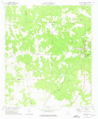
1971 Map of Ideal South
USGS Topo · Published 1973About this map
The boundary between Macon County and Schley County divides this rural landscape, which is defined by an extensive network of waterways and small community centers. Early 1970s land use is centered around the Seaboard Coast Line railroad and the crossroads at Ideal and Fountainville. The terrain is deeply carved by Buck Creek, Sand Creek, and Whitewater Creek, creating a complex topography that historically dictated the placement of homesteads and houses of worship. Numerous small churches serve the area, including Shady Grove Ch, Travel Home Ch, and Davis Chapel. Near the southeastern corner, the English Millpond and its adjacent English Cem reflect the localized industries and family legacies that shaped this portion of Central Georgia during the post-war era.
Find a feature on this map
23 named features on this map. Tap any name to fly to it.
Don’t see what you’re looking for? This feature index may not catch every label — zoom into the map to look around manually.
Map Details
Editions of this 1971 Ideal South Map
This is the sole edition of this map. No revisions or reprints were ever made.
Other maps of this area

1955 · Phenix City
USGS Topo · 1:250,000

1957 · Phenix City
USGS Topo · 1:250,000

1958 · Phenix City
USGS Topo · 1:250,000

1971 · Rupert
USGS Topo · 1:24,000

1971 · Ideal North
USGS Topo · 1:24,000

1971 · Ellaville North
USGS Topo · 1:24,000

1971 · Garden Valley
USGS Topo · 1:24,000

1971 · Montezuma
USGS Topo · 1:24,000

1972 · Ellaville South
USGS Topo · 1:24,000
1972 · Andersonville
USGS Topo · 1:24,000