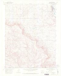
1968 Map of Ignacio
USGS Topo · Published 1972About this map
The town of Ignacio serves as a hub for the Southern Ute Indian Reservation in this late 1960s landscape, situated along the Los Pinos River (also labeled the Pine River). The map documents the community's layout, including the Memorial Cem, Rodeo Ground, and the local sewage disposal ponds. An Old Railroad Grade traces a path through the northeastern corner, marking the shift in transportation infrastructure as the region turned toward natural resource extraction.
Find a feature on this map
29 named features on this map. Tap any name to fly to it.
Don’t see what you’re looking for? This feature index may not catch every label — zoom into the map to look around manually.
Map Details
Editions of this 1968 Ignacio Map
This is the sole edition of this map. No revisions or reprints were ever made.
Other maps of this area

1889 · Largo
USGS Topo · 1:250,000

1895 · Largo
USGS Topo · 1:250,000

1908 · Ignacio
USGS Topo · 1:125,000

1924 · Ignacio
USGS Topo · 1:125,000

1945 · Durango
USGS Topo · 1:250,000

1953 · Durango
USGS Topo · 1:250,000

1954 · Durango
USGS Topo · 1:250,000
1954 · Burnt Mesa
USGS Topo · 1:24,000

1954 · Aztec
USGS Topo · 1:250,000

1958 · Aztec
USGS Topo · 1:250,000