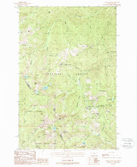
1988 Map of Illinois Peak
USGS Topo · Published 1988About this map
The high Bitterroot Divide defines this 1988 survey, marking the state line between Shoshone County, Idaho, and Mineral County, Montana. This high-altitude landscape is dominated by the intersecting boundaries of the Lolo National Forest, St Joe National Forest, and Clearwater National Forest. Exploration and extraction have left a clear mark on the terrain, evidenced by several mining sites like the Gildersleeve Mine, Amador Mine, and Cinkers Mine, alongside numerous unnamed prospects and adits concentrated around Snowshoe Gulch.
Find a feature on this map
65 named features on this map. Tap any name to fly to it.
Don’t see what you’re looking for? This feature index may not catch every label — zoom into the map to look around manually.
Map Details
Editions of this 1988 Illinois Peak Map
This is the sole edition of this map. No revisions or reprints were ever made.
Other maps of this area

1911 · Lolo
USGS Topo · 1:250,000

1913 · Lolo
USGS Topo · 1:250,000

1918 · St Regis
USGS Topo · 1:125,000

1919 · St. Regis
USGS Topo · 1:125,000

1956 · Wallace
USGS Topo · 1:250,000

1956 · Hamilton
USGS Topo · 1:250,000

1957 · Illinois Peak
USGS Topo · 1:62,500

1959 · Hamilton
USGS Topo · 1:250,000

1960 · Wallace
USGS Topo · 1:250,000

1960 · Hamilton
USGS Topo · 1:250,000