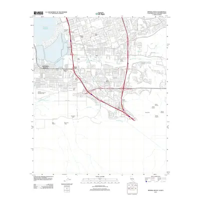
2012 Map of Imperial Beach
USGS Topo · Published 2012About this map
Imperial Beach and its surrounding South Bay neighborhoods are captured here just north of the international boundary during a period of dense suburban and industrial expansion. The coastal landscape is anchored by the Imperial Beach Naval Outlying Field (Ream Field) and the tidal outlets of the Tijuana River. Moving inland, the map details the infrastructure of San Ysidro and Otay Mesa, showing how Interstate 5 and Interstate 805 carved through older established communities like Nestor, Palm City, and Fruitdale. These major transit corridors bridge the gap between the residential blocks of South San Diego and the undeveloped terrain of Spooners Mesa and Smuggler Gulch to the south. Local heritage sites, including the Mount Olivet Cem, sit adjacent to the winding course of the Otay River, illustrating the intersection of natural drainage and modern development.
Find a feature on this map
31 named features on this map. Tap any name to fly to it.
Don’t see what you’re looking for? This feature index may not catch every label — zoom into the map to look around manually.
Map Details
Editions of this 2012 Imperial Beach Map
This is the sole edition of this map. No revisions or reprints were ever made.
Other maps of this area

1903 · Cuyamaca
USGS Topo · 1:125,000

1904 · San Diego
USGS Topo · 1:62,500

1904 · Southern California Sheet No. 2
USGS Topo · 1:250,000

1930 · San Diego
USGS Topo · 1:62,500

1942 · Point Loma
USGS Topo · 1:31,680
1943 · San Ysidro
USGS Topo · 1:31,680

1943 · Jamul
USGS Topo · 1:62,500
1944 · National City
USGS Topo · 1:31,680

1950 · San Diego
USGS Topo · 1:250,000
1953 · San Ysidro
USGS Topo · 1:24,000