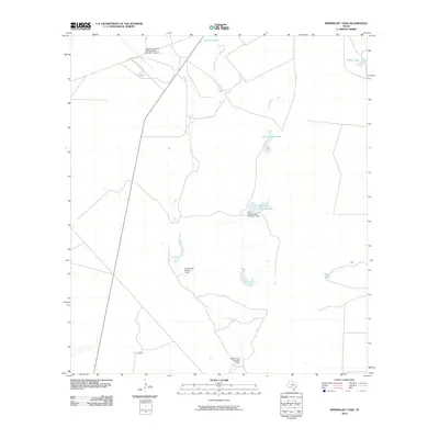
2010 Map of Imperialist Tank
USGS Topo · Published 2010About this map
Laughlin Air Force Base Auxiliary Number 1 Airport dominates the northwestern corner of this South Texas landscape, serving as a prominent military aviation landmark in a region defined by its water management systems. The terrain is structured around a network of stock tanks and artificial reservoirs essential for ranching and land use in this arid environment. Key water features include Imperialist Creek and Elm Creek, which feed into various named tanks such as Flat Tank, Johnson Tank, and County Line Tank. This 2010 survey highlights the local engineering of the late 20th and early 21st centuries, specifically the Burr Estate Lake Number 1 and its associated dam, alongside the Smyth Lake Number 1 and Smyth Lake Number 2 systems, illustrating how the landscape has been adapted for water storage and estate management in Maverick County.
Find a feature on this map
13 named features on this map. Tap any name to fly to it.
Don’t see what you’re looking for? This feature index may not catch every label — zoom into the map to look around manually.
Map Details
Editions of this 2010 Imperialist Tank Map
This is the sole edition of this map. No revisions or reprints were ever made.
Other maps of this area

1896 · Brackett
USGS Topo · 1:125,000

1897 · Brackett
USGS Topo · 1:125,000

1940 · Paloma
USGS Topo · 1:62,500

1940 · Quemado
USGS Topo · 1:62,500

1941 · Tequesquite Creek
USGS Topo · 1:62,500

1944 · Tequesquite Creek
USGS Topo · 1:62,500

1944 · Spofford
USGS Topo · 1:62,500

1958 · Eagle Pass
USGS Topo · 1:250,000

1958 · Del Rio
USGS Topo · 1:250,000

1964 · Del Rio
USGS Topo · 1:250,000