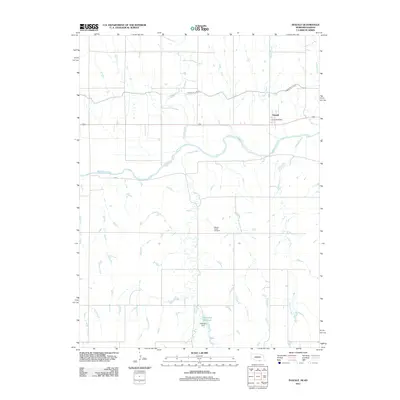
2011 Map of Inavale
USGS Topo · Published 2011About this map
The settlement of Inavale serves as the focal point of this agricultural landscape in southern Nebraska, where the Inavale Post Office remains a central landmark. The geography is defined by the braided path of the Republican River, which flows eastward, joined by numerous tributaries including Walnut Creek and Spring Creek. Human management of this water-rich environment is evident through the presence of the Franklin Canal in the northern portion of the quadrangle and the Talkington Reservoir, held by the Talkington Dam to the south. Local history is anchored at the Walnut Creek Cemetery, which sits along the creek's winding path south of the main town. The survey illustrates the systematic grid of rural roads and the reliance on irrigation and drainage systems that support the regional farming economy.
Find a feature on this map
13 named features on this map. Tap any name to fly to it.
Don’t see what you’re looking for? This feature index may not catch every label — zoom into the map to look around manually.
Map Details
Editions of this 2011 Inavale Map
This is the sole edition of this map. No revisions or reprints were ever made.
Other maps of this area

1893 · Smith Center
USGS Topo · 1:125,000

1897 · Red Cloud
USGS Topo · 1:125,000

1940 · Red Cloud
USGS Topo · 1:62,500

1942 · Red Cloud
USGS Topo · 1:62,500

1955 · Grand Island
USGS Topo · 1:250,000

1955 · Beloit
USGS Topo · 1:250,000

1957 · Grand Island
USGS Topo · 1:250,000

1958 · Grand Island
USGS Topo · 1:250,000

1959 · Beloit
USGS Topo · 1:250,000
1973 · Cora
USGS Topo · 1:24,000