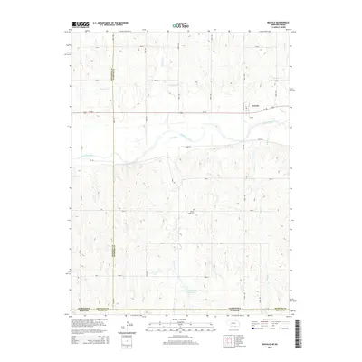
2014 Map of Inavale
USGS Topo · Published 2014About this map
Inavale sits north of the Republican River in a landscape defined by the intersection of riparian lowlands and the rolling hills of the Nebraska-Kansas border. This area showcases a sophisticated irrigation and water management network, anchored by the Franklin Canal and punctuated by the Talkington Reservoir. The terrain is deeply dissected by numerous north-south drainages, including Spring Cr, School Cr, and Farmers Cr, which feed toward the river valley. Evidence of local heritage remains visible at the Walnut Creek Cem, located in the southern portion of the quadrangle. The map captures the precise boundary where Webster and Franklin counties in Nebraska meet Smith County in Kansas, illustrating how early land surveys and transportation routes like Us-136 followed the natural contours of the river valley while the surrounding section-line roads impose a strict grid upon the broken prairie topography.
Find a feature on this map
35 named features on this map. Tap any name to fly to it.
Don’t see what you’re looking for? This feature index may not catch every label — zoom into the map to look around manually.
Map Details
Editions of this 2014 Inavale Map
This is the sole edition of this map. No revisions or reprints were ever made.
Other maps of this area

1893 · Smith Center
USGS Topo · 1:125,000

1897 · Red Cloud
USGS Topo · 1:125,000

1940 · Red Cloud
USGS Topo · 1:62,500

1942 · Red Cloud
USGS Topo · 1:62,500

1955 · Grand Island
USGS Topo · 1:250,000

1955 · Beloit
USGS Topo · 1:250,000

1957 · Grand Island
USGS Topo · 1:250,000

1958 · Grand Island
USGS Topo · 1:250,000

1959 · Beloit
USGS Topo · 1:250,000
1973 · Cora
USGS Topo · 1:24,000