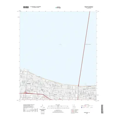
2020 Map of Indian Beach
USGS Topo · Published 2020About this map
Lake Pontchartrain dominates the northern horizon of this Jefferson Parish landscape, where the massive Lake Pontchartrain Causeway begins its transit across the water. The suburban development of Kenner and surrounding residential districts like Bissonet Plaza and Westgate occupy the land between the lakeshore and the sprawling grounds of the Louis Armstrong New Orleans International Airport. This modern layout reveals a dense grid of residential streets, such as Vintage Dr and W Esplanade Ave, intersected by drainage infrastructure including the Bissonet Canal. Along the shoreline to the east, the communities of Bucktown, Indian Beach, and Bonnabel Place sit behind the protective levee system. The map provides a detailed look at the infrastructure supporting this low-lying region, from the higher ground of the airport to the various neighborhood schools and colleges like Herzing College that serve these established Louisiana suburbs.
Find a feature on this map
69 named features on this map. Tap any name to fly to it.
Don’t see what you’re looking for? This feature index may not catch every label — zoom into the map to look around manually.
Map Details
Editions of this 2020 Indian Beach Map
This is the sole edition of this map. No revisions or reprints were ever made.
Other maps of this area

1891 · Hahnville
USGS Topo · 1:62,500

1891 · Spanish Fort
USGS Topo · 1:62,500

1891 · New Orleans
USGS Topo · 1:62,500

1892 · Bonnet Carre
USGS Topo · 1:62,500

1932 · New Orleans NE
USGS Topo · 1:31,680

1932 · New Orleans NW
USGS Topo · 1:31,680

1932 · Hahnville NE
USGS Topo · 1:31,680

1935 · Luling
USGS Topo · 1:31,680

1936 · Bonnet Carre
USGS Topo · 1:62,500

1936 · Spanish Fort
USGS Topo · 1:62,500