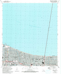
1992 Map of Indian Beach
USGS Topo · Published 1992About this map
The southern shore of Lake Pontchartrain dominates this early 1990s record of Jefferson Parish, defined by a dense suburban grid and critical water management infrastructure. A series of pumping stations, including Pumping Sta No 4 and Pumping Sta No 1, maintain the landscape between the Seawall and the inland residential developments of Kenner and Metairie. The map shows a transition from recreation and commerce at the Jefferson Downs Racetrack and the Bissonet Maned Downs Country Club to the large-scale public space of Lafreniere Park.
Find a feature on this map
52 named features on this map. Tap any name to fly to it.
Don’t see what you’re looking for? This feature index may not catch every label — zoom into the map to look around manually.
Map Details
Editions of this 1992 Indian Beach Map
This is the sole edition of this map. No revisions or reprints were ever made.
Other maps of this area

1891 · Hahnville
USGS Topo · 1:62,500

1891 · Spanish Fort
USGS Topo · 1:62,500

1891 · New Orleans
USGS Topo · 1:62,500

1892 · Bonnet Carre
USGS Topo · 1:62,500

1932 · New Orleans NE
USGS Topo · 1:31,680

1932 · New Orleans NW
USGS Topo · 1:31,680

1932 · Hahnville NE
USGS Topo · 1:31,680

1935 · Luling
USGS Topo · 1:31,680

1936 · Bonnet Carre
USGS Topo · 1:62,500

1936 · Spanish Fort
USGS Topo · 1:62,500