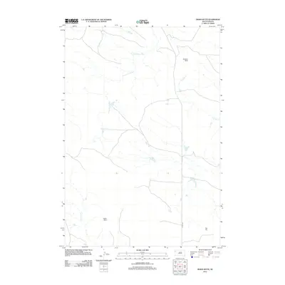
2012 Map of Indian Butte
USGS Topo · Published 2012About this map
S Fork Moreau River meanders across this northern South Dakota landscape, providing the primary drainage for a territory defined by isolated landmarks and prairie horizons. The hydrology is further shaped by tributaries like Fourmile Cr and Indian Cr, which cut through the open terrain between prominent high points. Notable elevations such as Gustave Butte and Indian Butte serve as distinct navigational markers in this sparsely populated region. The local infrastructure is minimal, centered on Co Hwy-752 and a network of rural roads that connect the isolated ranches and open range of Butte County. The presence of Flat Top in the southeast corner emphasizes the tabletop geology characteristic of the western plains during the early 21st century.
Find a feature on this map
7 named features on this map. Tap any name to fly to it.
Don’t see what you’re looking for? This feature index may not catch every label — zoom into the map to look around manually.
Map Details
Editions of this 2012 Indian Butte Map
This is the sole edition of this map. No revisions or reprints were ever made.
Other maps of this area

1935 · Harding
USGS Topo · 1:125,000

1954 · Lemmon
USGS Topo · 1:250,000

1954 · Ekalaka
USGS Topo · 1:250,000

1956 · Ekalaka
USGS Topo · 1:250,000

1957 · Lemmon
USGS Topo · 1:250,000

1958 · Ekalaka
USGS Topo · 1:250,000

1965 · Ekalaka
USGS Topo · 1:250,000

1973 · Hells Canyon
USGS Topo · 1:24,000
1977 · Greasewood Draw
USGS Topo · 1:24,000
1978 · Indian Butte
USGS Topo · 1:24,000