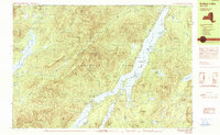
1990 Map of Indian Lake
USGS Topo · Published 1990About this map
Snowy Mountain and the high ridges of the Adirondack Park dominate this central Hamilton County landscape during the late 20th century. The settlement of Sabael sits on the western shore of Indian Lake, serving as a primary point of access for the numerous campsites scattered along the water's edge and across The Narrows. This period shows a well-established recreational infrastructure, including the Indian Lake State Campground and the Indian Lake Islands State Campground, reflecting the area's long-standing role as a destination for outdoor enthusiasts.
Find a feature on this map
77 named features on this map. Tap any name to fly to it.
Don’t see what you’re looking for? This feature index may not catch every label — zoom into the map to look around manually.
Map Details
Editions of this 1990 Indian Lake Map
This is the sole edition of this map. No revisions or reprints were ever made.
Other maps of this area

1898 · Newcomb
USGS Topo · 1:62,500

1898 · Thirteenth Lake
USGS Topo · 1:62,500

1899 · Indian Lake
USGS Topo · 1:62,500

1900 · Canada Lake
USGS Topo · 1:62,500

1901 · Newcomb
USGS Topo · 1:62,500

1902 · Indian Lake
USGS Topo · 1:62,500

1903 · West Canada Lakes
USGS Topo · 1:62,500

1903 · Raquette Lake
USGS Topo · 1:62,500

1903 · Blue Mountain
USGS Topo · 1:62,500

1950 · Utica
USGS Topo · 1:250,000