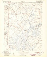
1951 Map of Indian Mills
USGS Topo · Published 1951About this map
The lowlands of Burlington County are defined by an extensive network of Cranberry Bog operations that dominate the landscape between Indian Mills and Tabernacle. This 1951 record shows the intricate drainage system of the Batsto River and Friendship Creek, where water management was central to the local agricultural economy. Small settlements like Bozuretown, Oriental, and Fox Chase are scattered throughout the pine woods, often situated near water sources like Bread and Cheese Run or Springers Brook.
Find a feature on this map
40 named features on this map. Tap any name to fly to it.
Don’t see what you’re looking for? This feature index may not catch every label — zoom into the map to look around manually.
Map Details
Editions of this 1951 Indian Mills Map
2 editions found
Other maps of this area

1888 · Pemberton
USGS Topo · 1:62,500

1888 · Mount Holly
USGS Topo · 1:62,500

1890 · Hammonton
USGS Topo · 1:62,500

1890 · Mullica
USGS Topo · 1:62,500

1894 · Hammonton
USGS Topo · 1:62,500

1894 · Pemberton
USGS Topo · 1:62,500

1894 · Mount Holly
USGS Topo · 1:62,500

1894 · Mullica
USGS Topo · 1:62,500

1898 · Pemberton
USGS Topo · 1:62,500

1898 · Mount Holly
USGS Topo · 1:62,500
Featured Places
- Southampton Township, NJ
- Tabernacle Township, NJ
- Shamong Township, NJ
- Meadford Farms, Tabernacle Township
- Oriental, Tabernacle Township