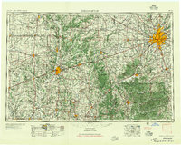
1957 Map of Indianapolis
USGS Topo · Published 1957About this map
Indianapolis serves as the central hub of this mid-1950s regional landscape, with its urban footprint expanding toward Speedway and the enclave of Woodruff Place. The map reveals a post-war landscape defined by massive industrial and military installations, most notably the Wabash River Ordnance Works near Terre Haute and the sprawling Camp Atterbury to the south. Transportation networks are dominated by the great mid-century railroads like the Pennsylvania RR and the Monon RR, which crisscross the agricultural heartland between the Wabash River and the White River.
Find a feature on this map
253 named features on this map. Tap any name to fly to it.
Don’t see what you’re looking for? This feature index may not catch every label — zoom into the map to look around manually.
Map Details
Editions of this 1957 Indianapolis Map
2 editions found

Other maps of this area

1899 · Danville
USGS Topo · 1:62,500

1900 · Danville
USGS Topo · 1:62,500

1906 · Urbana
USGS Topo · 1:62,500

1908 · Clay City
USGS Topo · 1:48,000

1908 · Bloomington
USGS Topo · 1:48,000

1908 · Bloomfield
USGS Topo · 1:62,500

1910 · Clay City
USGS Topo · 1:62,500

1910 · Hardinville
USGS Topo · 1:62,500

1910 · Bloomington
USGS Topo · 1:62,500

1917 · Birds
USGS Topo · 1:62,500