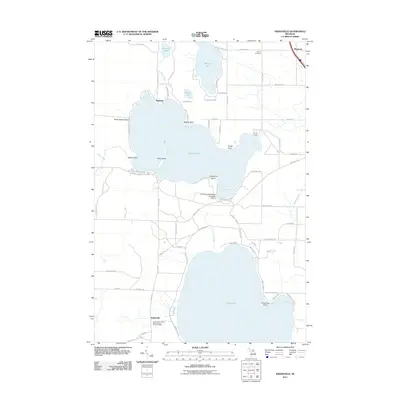
2011 Map of Indianville
USGS Topo · Published 2011About this map
The glacial waters of northern Michigan dominate this landscape, where Douglas Lake and Burt Lake serve as the primary geographical anchors. Along the southern shores of Douglas Lake, the University of Michigan Biological Station stands as a focal point for environmental study, established amidst a network of sandy points like Grapevine Point and Sedge Point. The settlement of Indianville is situated to the southwest, marked by the Assumption of the Blessed Virgin Mary Cemetery, reflecting the area's spiritual and community history. To the north, smaller bodies of water such as Munro Lake, Vincent Lake, and Lancaster Lake are surrounded by a grid of local roads and recreational sites like Camp Knight. This survey captures the transition between lakeside residential clusters at Ingleside and Weadock and the dense creek systems, including Little Carp River and Van Creek, that feed the larger lakes.
Find a feature on this map
78 named features on this map. Tap any name to fly to it.
Don’t see what you’re looking for? This feature index may not catch every label — zoom into the map to look around manually.
Map Details
Editions of this 2011 Indianville Map
This is the sole edition of this map. No revisions or reprints were ever made.
Other maps of this area

1955 · Cheboygan
USGS Topo · 1:250,000

1957 · Wolverine
USGS Topo · 1:62,500

1957 · Mullett Lake
USGS Topo · 1:62,500

1958 · Cheboygan
USGS Topo · 1:250,000

1958 · Pellston
USGS Topo · 1:62,500

1958 · Petoskey
USGS Topo · 1:62,500

1975 · Petoskey NE
USGS Topo · 1:24,000

1982 · Petoskey
USGS Topo · 1:100,000
1982 · Levering
USGS Topo · 1:25,000

1982 · Pellston
USGS Topo · 1:25,000