
1957 Map of International Falls
USGS Topo · Published 1957About this map
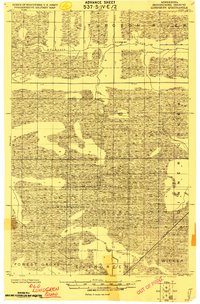
Fort Frances and International Falls anchor this mid-century cross-border survey, illustrating the industrial and transport hub where the Rainy River flows from Rainy Lake. The landscape is dominated by a complex network of waterways and islands, including Mackenzie Island and Dryweed Island, set against the backdrop of extensive timber and wilderness lands. The mapping reveals a geography defined by political and cultural boundaries, featuring several indigenous lands such as the Nett Lake Indian Reservation and various Rainy Lake Indian Reserves. Transportation corridors are clearly delineated, with the Canadian National and Northern Pacific RR linking border towns to the interior. This era shows the region before the modernization of its remote corridors, highlighting small logging and rail settlements like Big Falls and Margie along the southern edge of the Koochiching County line.
Find a feature on this map
172 named features on this map. Tap any name to fly to it.
Don’t see what you’re looking for? This feature index may not catch every label — zoom into the map to look around manually.
Map Details
Editions of this 1957 International Falls Map
This is the sole edition of this map. No revisions or reprints were ever made.
Other maps of this area

1918 · Zora
USGS Topo · 1:62,500

1919 · Zora
USGS Topo · 1:62,500
1919 · Lundgren
USGS Topo · 1:62,500

1919 · Gemmell
USGS Topo · 1:62,500
1919 · Pelland
USGS Topo · 1:62,500

1919 · Birchdale
USGS Topo · 1:62,500

1919 · I
USGS Topo · 1:62,500

1919 · Happy Land
USGS Topo · 1:62,500

1919 · M
USGS Topo · 1:62,500

1919 · Margie
USGS Topo · 1:62,500