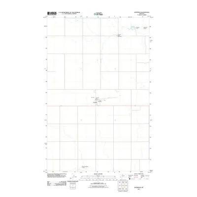
2011 Map of Inverness
USGS Topo · Published 2011About this map
The small settlement of Inverness serves as the focal point of this northern Montana landscape, situated along the east-west highway and centered around essential local services like the Inverness Post Office and the Inverness Rural Fire Dept. The surrounding terrain is defined by dry-land drainage systems and water management infrastructure, including the East Fork Black Coulee to the south and Hingham Coulee to the north. Agriculture and water storage are central to the area's layout, evidenced by features such as the Prescott Reservoir and its associated Prescott Dam, alongside the Hingham Sandy Sage Dam. This map provides a look at the rural organization of Hill County in the early 21st century, where the grid of local routes like Inverness Rd connects isolated homesteads to the village core.
Find a feature on this map
11 named features on this map. Tap any name to fly to it.
Don’t see what you’re looking for? This feature index may not catch every label — zoom into the map to look around manually.
Map Details
Editions of this 2011 Inverness Map
This is the sole edition of this map. No revisions or reprints were ever made.
Other maps of this area

1919 · Alma
USGS Topo · 1:125,000

1954 · Shelby
USGS Topo · 1:250,000

1958 · Shelby
USGS Topo · 1:250,000

1963 · Joplin
USGS Topo · 1:24,000

1963 · Chester NE
USGS Topo · 1:24,000

1970 · Poverty Coulee NE
USGS Topo · 1:24,000

1970 · Rocky Coulee
USGS Topo · 1:24,000
1970 · Een School
USGS Topo · 1:24,000
1972 · Rudyard
USGS Topo · 1:24,000

1972 · Rudyard NW
USGS Topo · 1:24,000