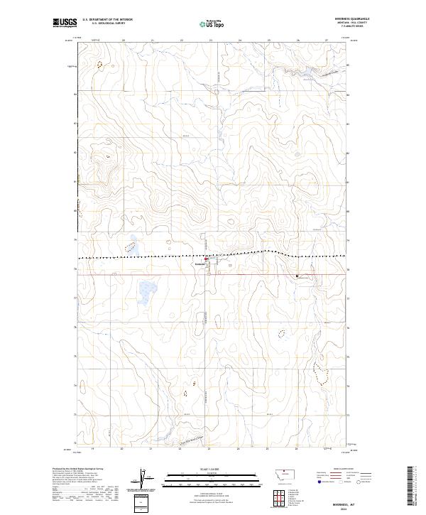
2024 Map of Inverness
USGS Topo · Published 2024About this map
The settlement of Inverness serves as the central hub of this northern Montana landscape, situated within Hill County. The town plan is clearly defined by a grid of local thoroughfares including Main St, 1st St, and 2nd St, reflecting the structured land divisions of the High Line region. To the east, the Inverness Cem provides a point of significant interest for genealogists and local historians documenting the families of this agricultural community.
Find a feature on this map
20 named features on this map. Tap any name to fly to it.
Don’t see what you’re looking for? This feature index may not catch every label — zoom into the map to look around manually.
Map Details
Editions of this 2024 Inverness Map
This is the sole edition of this map. No revisions or reprints were ever made.
Other maps of this area

1919 · Alma
USGS Topo · 1:125,000

1954 · Shelby
USGS Topo · 1:250,000

1958 · Shelby
USGS Topo · 1:250,000

1963 · Joplin
USGS Topo · 1:24,000

1963 · Chester NE
USGS Topo · 1:24,000

1970 · Poverty Coulee NE
USGS Topo · 1:24,000

1970 · Rocky Coulee
USGS Topo · 1:24,000
1970 · Een School
USGS Topo · 1:24,000
1972 · Rudyard
USGS Topo · 1:24,000

1972 · Rudyard NW
USGS Topo · 1:24,000