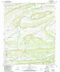
1987 Map of Ione
USGS Topo · Published 1988About this map
Petit Jean River winds through the heart of this Arkansas landscape, defining the valley between the prominent elevations of Sand Ridge to the north and Boney Mountain to the south. Small communities like Lucas, Ione, and Boothe are connected by a network of rural roads, with the Ouachita National Forest bordering the southern edge of the survey area. The presence of numerous family-named cemeteries, including Bloodsworth Cem and Wiley Cem, indicates a deep-rooted lineage of local settlement and land ownership.
Find a feature on this map
41 named features on this map. Tap any name to fly to it.
Don’t see what you’re looking for? This feature index may not catch every label — zoom into the map to look around manually.
Map Details
Editions of this 1987 Ione Map
This is the sole edition of this map. No revisions or reprints were ever made.
Other maps of this area

1879 · Poteau Mountain
USGS Topo · 1:62,500

1887 · Poteau Mountain #1
USGS Topo · 1:62,500

1887 · Mount Ida #2
USGS Topo · 1:62,500

1887 · Magazine Mountain #3
USGS Topo · 1:62,500

1887 · Magazine Mountain
USGS Topo · 1:62,500

1890 · Magazine Mountain
USGS Topo · 1:125,000

1890 · Mount Ida
USGS Topo · 1:125,000

1890 · Fort Smith
USGS Topo · 1:125,000

1890 · Poteau Mountain
USGS Topo · 1:125,000

1899 · Poteau Mountain
USGS Topo · 1:125,000