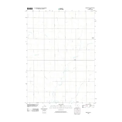
2010 Map of Ireton SW
USGS Topo · Published 2010About this map
Ruble and Adaville anchor this portion of Plymouth County, where the Northwest Iowa landscape is defined by a systematic grid of section roads and a complex network of prairie streams. The area is dominated by the winding course of Broken Kettle Creek, which flows through the central and southern reaches of the quadrangle, joined by tributaries such as Bull Run and Westfield Creek. This 2010 survey reflects a deeply established agricultural pattern, where the road network, including Fawn Ave and Evergreen Ave, adheres strictly to the township and range lines established over a century prior. Genealogists and local historians will find the Saint Johns Lutheran Cemetery in the northeastern corner, a significant landmark for tracing early families in this rural community. The map provides a clear record of land use and drainage patterns, from the headwaters of Beaver Creek to the various unnamed farmsteads that dot the Iowa countryside.
Find a feature on this map
21 named features on this map. Tap any name to fly to it.
Don’t see what you’re looking for? This feature index may not catch every label — zoom into the map to look around manually.
Map Details
Editions of this 2010 Ireton SW Map
This is the sole edition of this map. No revisions or reprints were ever made.
Other maps of this area

1898 · Elk Point
USGS Topo · 1:125,000

1901 · Elk Point
USGS Topo · 1:125,000

1907 · Elk Point
USGS Topo · 1:125,000

1955 · Sioux City
USGS Topo · 1:250,000

1958 · Sioux City
USGS Topo · 1:250,000

1959 · Sioux City
USGS Topo · 1:250,000

1963 · Elk Point NE
USGS Topo · 1:24,000

1964 · Hinton
USGS Topo · 1:24,000
1964 · Millnerville
USGS Topo · 1:24,000
1969 · Chatsworth
USGS Topo · 1:24,000