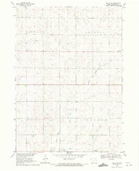
1969 Map of Ireton SW
USGS Topo · Published 1971About this map
Broken Kettle Creek and Beaver Creek define the drainage of this rural Plymouth County landscape during the late 1960s. The area is divided into the civil townships of Portland, Preston, Westfield, and Johnson, reflecting a traditional Midwestern section-line grid. Small social and commercial hubs are sparse but significant, centered around the settlement of Ruble near the center of the sheet and Adaville in the southeastern corner. Religious life is anchored at St Johns Ch on the eastern edge of the Preston township line.
Find a feature on this map
11 named features on this map. Tap any name to fly to it.
Don’t see what you’re looking for? This feature index may not catch every label — zoom into the map to look around manually.
Map Details
Editions of this 1969 Ireton SW Map
This is the sole edition of this map. No revisions or reprints were ever made.
Other maps of this area

1898 · Elk Point
USGS Topo · 1:125,000

1901 · Elk Point
USGS Topo · 1:125,000

1907 · Elk Point
USGS Topo · 1:125,000

1955 · Sioux City
USGS Topo · 1:250,000

1958 · Sioux City
USGS Topo · 1:250,000

1959 · Sioux City
USGS Topo · 1:250,000

1963 · Elk Point NE
USGS Topo · 1:24,000

1964 · Hinton
USGS Topo · 1:24,000
1964 · Millnerville
USGS Topo · 1:24,000
1969 · Chatsworth
USGS Topo · 1:24,000