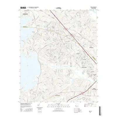
2017 Map of Irmo
USGS Topo · Published 2017About this map
Irmo and the surrounding residential communities of Seven Oaks and Whitehall define the suburban landscape between the Saluda River and Broad River northwest of Columbia. The map documents the extensive development around the eastern edge of Lake Murray, including the prominent Rocky Point and various bays like Lake Murray of Richland. This area, split by the Richland and Lexington county line, shows a complex network of creeks such as Rawls Cr, Kinley Cr, and Twelvemile Cr that drain the undulating terrain into the larger river systems. Genealogists will find several notable burial sites preserved amidst the modern street grids, including Bauknight Cem, Salem Cem, and both the Upper Pine Grove Cem and Lower Pine Grove Cem. The presence of established neighborhoods like Challedon and Woodland Hills illustrates the post-war growth of the region, while landmarks like Corley Millpond and Corley Island point to the area's older hydraulic and geographic history.
Find a feature on this map
295 named features on this map. Tap any name to fly to it.
Don’t see what you’re looking for? This feature index may not catch every label — zoom into the map to look around manually.
Map Details
Editions of this 2017 Irmo Map
This is the sole edition of this map. No revisions or reprints were ever made.
Other maps of this area

1904 · Columbia
USGS Topo · 1:125,000

1941 · Spartanburg
USGS Topo · 1:250,000

1944 · Gilbert
USGS Topo · 1:62,500

1944 · Edmund
USGS Topo · 1:62,500

1946 · Irmo
USGS Topo · 1:24,000

1947 · Columbia North
USGS Topo · 1:24,000

1947 · Richtex
USGS Topo · 1:24,000

1948 · Irmo
USGS Topo · 1:24,000

1948 · Columbia North
USGS Topo · 1:24,000

1949 · Richtex
USGS Topo · 1:24,000