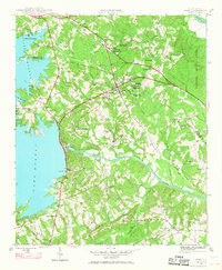
1946 Map of Irmo
USGS Topo · Published 1968About this map
The Saluda River and the massive expanse of Lake Murray define the landscape of this mid-1940s survey of the Richland Co and Lexington Co border. The dominance of the Dreher Shoals Dam and its associated Power House signifies the era's focus on hydroelectric development, which reshaped the geography near Irmo. Further inland, a dense network of local institutions highlights the rural social fabric, including the Harbison Institute and several local educational landmarks like Irmo Sch Dist No 40 and the Rosenwald Sch.
Find a feature on this map
45 named features on this map. Tap any name to fly to it.
Don’t see what you’re looking for? This feature index may not catch every label — zoom into the map to look around manually.
Map Details
Editions of this 1946 Irmo Map
This is the sole edition of this map. No revisions or reprints were ever made.
Other maps of this area

1904 · Columbia
USGS Topo · 1:125,000

1941 · Spartanburg
USGS Topo · 1:250,000
1944 · Gilbert
USGS Topo · 1:62,500

1944 · Edmund
USGS Topo · 1:62,500

1947 · Columbia North
USGS Topo · 1:24,000

1947 · Richtex
USGS Topo · 1:24,000
1948 · Irmo
USGS Topo · 1:24,000

1948 · Columbia North
USGS Topo · 1:24,000

1949 · Richtex
USGS Topo · 1:24,000

1949 · Irmo NE
USGS Topo · 1:24,000