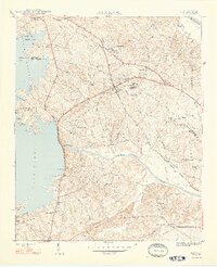
1948 Map of Irmo
USGS Topo · Published 1948About this map
Irmo and its surrounding rural communities are captured here just after the second World War, showing a landscape defined by the Columbia Newberry and Laurens railroad and the shoreline of Lake Murray. The presence of the Harbison Institute and the Rosenwold Sch near Golden Gem highlights significant educational landmarks for the era. The terrain is marked by a dense network of country churches and schools, including St Paul Ch, Mt Olive Ch, and Irmo Sch Dist No 45. To the south, the Saluda River flows below the Dreher Shoals Dam, with industrial infrastructure such as the Power House and Spillway 360 visible. The northern reaches include Harbison State Forest and the Ballentine Fire Tower, while the western edge is dominated by the rising waters and inlets of the reservoir near Ballentine Landing.
Find a feature on this map
45 named features on this map. Tap any name to fly to it.
Don’t see what you’re looking for? This feature index may not catch every label — zoom into the map to look around manually.
Map Details
Editions of this 1948 Irmo Map
2 editions found
Other maps of this area

1904 · Columbia
USGS Topo · 1:125,000

1941 · Spartanburg
USGS Topo · 1:250,000

1944 · Gilbert
USGS Topo · 1:62,500

1944 · Edmund
USGS Topo · 1:62,500

1946 · Irmo
USGS Topo · 1:24,000

1947 · Columbia North
USGS Topo · 1:24,000

1947 · Richtex
USGS Topo · 1:24,000

1948 · Irmo
USGS Topo · 1:24,000

1948 · Columbia North
USGS Topo · 1:24,000

1949 · Richtex
USGS Topo · 1:24,000