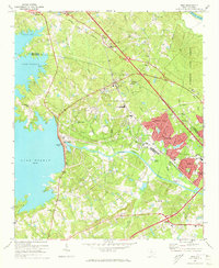
1971 Map of Irmo
USGS Topo · Published 1973About this map
Lake Murray dominates the western edge of this landscape, its irregular shoreline defined by points like Rocky Point and the community of Ballentine Landing. The 1971 revision documents a period of suburban expansion between the lake and the Broad River, particularly in the residential developments of Whitehall, Challedon, and Woodland Hills. The Columbia Newberry and Laurens railroad line cuts diagonally across the terrain, passing through the town of Irmo, which is shown with its cluster of schools including Irmo High Sch and the Harbison Institute.
Find a feature on this map
71 named features on this map. Tap any name to fly to it.
Don’t see what you’re looking for? This feature index may not catch every label — zoom into the map to look around manually.
Map Details
Editions of this 1971 Irmo Map
4 editions found
Other maps of this area

1904 · Columbia
USGS Topo · 1:125,000

1941 · Spartanburg
USGS Topo · 1:250,000

1944 · Gilbert
USGS Topo · 1:62,500

1944 · Edmund
USGS Topo · 1:62,500

1946 · Irmo
USGS Topo · 1:24,000

1947 · Columbia North
USGS Topo · 1:24,000

1947 · Richtex
USGS Topo · 1:24,000

1948 · Irmo
USGS Topo · 1:24,000

1948 · Columbia North
USGS Topo · 1:24,000

1949 · Richtex
USGS Topo · 1:24,000