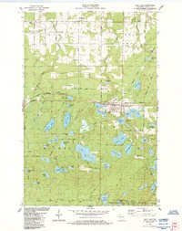
1984 Map of Iron Lake
USGS Topo · Published 1984About this map
Iron River serves as the primary hub of this northern Wisconsin landscape, situated where the Burlington Northern railroad corridor meets a dense network of glacial water bodies. The settlement's infrastructure includes the local Fairground, Sewage Disposal Ponds, and nearby Douglas Airpark. To the north, the township of Oulu is marked by the Oulu Sch and the Oulu Pioneer Memorial Park, reflecting the area's rural community roots and Scandinavian heritage.
Find a feature on this map
57 named features on this map. Tap any name to fly to it.
Don’t see what you’re looking for? This feature index may not catch every label — zoom into the map to look around manually.
Map Details
Editions of this 1984 Iron Lake Map
2 editions found
Other maps of this area

1943 · Iron Lake
USGS Topo · 1:48,000

1944 · Drummond
USGS Topo · 1:48,000

1945 · Highland
USGS Topo · 1:48,000

1947 · Drummond
USGS Topo · 1:48,000

1947 · Brule
USGS Topo · 1:48,000

1947 · Iron Lake
USGS Topo · 1:48,000

1949 · Highland
USGS Topo · 1:48,000

1953 · Ashland
USGS Topo · 1:250,000

1958 · Ashland
USGS Topo · 1:250,000

1961 · Iron Lake SW
USGS Topo · 1:24,000