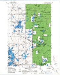
1961 Map of Iron Lake SE
USGS Topo · Published 1985About this map
Chequamegon National Forest dominates this landscape in northern Wisconsin, where a dense network of glacial lakes and wetlands defines the geography. The map reflects a mid-century period of forest management and outdoor recreation, featuring numerous boat access points and campgrounds near Long Lake and Twin Bear Lake. To the north, the Moquah Barrens Wildlife Area highlights a distinct ecological zone, while the Northern Pacific railroad line and a prominent Pipeline corridor cut through the timberland. Genealogical interest is centered on Tripp Cem near the northern boundary. Smaller water bodies like Steckbaur Lake, Hicks Lake, and Five Island Lake are scattered throughout the Washburn Ranger District, illustrating the complex hydrology of the region before significant modern development altered these shores.
Find a feature on this map
49 named features on this map. Tap any name to fly to it.
Don’t see what you’re looking for? This feature index may not catch every label — zoom into the map to look around manually.
Map Details
Editions of this 1961 Iron Lake SE Map
This is the sole edition of this map. No revisions or reprints were ever made.
Other maps of this area

1943 · Iron Lake
USGS Topo · 1:48,000

1944 · Moquah
USGS Topo · 1:48,000

1944 · Drummond
USGS Topo · 1:48,000

1944 · Grandview
USGS Topo · 1:48,000

1947 · Drummond
USGS Topo · 1:48,000

1947 · Moquah
USGS Topo · 1:48,000

1947 · Iron Lake
USGS Topo · 1:48,000

1947 · Grandview
USGS Topo · 1:48,000

1953 · Ashland
USGS Topo · 1:250,000

1958 · Ashland
USGS Topo · 1:250,000