
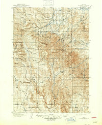
1908 Map of Ironside Mountain
USGS Topo · Published 1908About this map
Malheur National Forest dominates this early twentieth-century landscape, a rugged expanse where the headwaters of the Burnt River and Malheur River carve through high desert and timberland. The settlement pattern of 1908 is defined by isolated outposts and agricultural hubs like Hereford and Unity, while the interior of the quadrangle is marked by ranching operations including Tureman's Ranch and Wilson's Ranch. These family-named landmarks, along with Otis Sawmill, reflect a frontier economy dependent on timber and livestock.
Find a feature on this map
78 named features on this map. Tap any name to fly to it.
Don’t see what you’re looking for? This feature index may not catch every label — zoom into the map to look around manually.
Map Details
Editions of this 1908 Ironside Mountain Map
2 editions found
Other maps of this area

1901 · Baker City
USGS Topo · 1:125,000

1901 · Sumpter
USGS Topo · 1:125,000

1951 · Bates
USGS Topo · 1:62,500

1955 · Baker
USGS Topo · 1:250,000

1955 · Burns
USGS Topo · 1:250,000

1955 · Canyon City
USGS Topo · 1:250,000

1955 · Boise
USGS Topo · 1:250,000

1958 · Burns
USGS Topo · 1:250,000

1958 · Boise
USGS Topo · 1:250,000

1959 · Baker
USGS Topo · 1:250,000