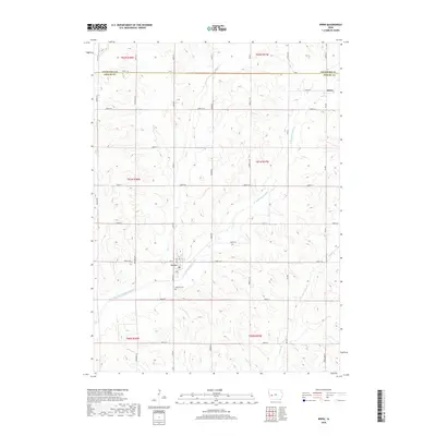
2018 Map of Irwin
USGS Topo · Published 2018About this map
The town of Irwin serves as a central hub in this section of Shelby County, situated along the banks of the West Nishnabotna River. The landscape is defined by the winding paths of the river and its tributaries, including Elk Cr and Long Br, which carve through the agricultural uplands. Evidence of late-twentieth-century rural organization is seen in the grid of numbered township roads, such as 2200th St and 340th St, which connect dispersed farmsteads to the primary corridors of Street F16 and Street F24. Further north, the small settlement of Botna sits near the Crawford County line. Local heritage is preserved at sites like Oak Hill Cemetery, while the town of Irwin itself shows a established street plan featuring Front St, Ann St, and Cora St.
Find a feature on this map
43 named features on this map. Tap any name to fly to it.
Don’t see what you’re looking for? This feature index may not catch every label — zoom into the map to look around manually.
Map Details
Editions of this 2018 Irwin Map
This is the sole edition of this map. No revisions or reprints were ever made.
Other maps of this area

1954 · Omaha
USGS Topo · 1:250,000

1957 · Omaha
USGS Topo · 1:250,000

1958 · Omaha
USGS Topo · 1:250,000

1971 · Earling NE
USGS Topo · 1:24,000

1971 · Defiance
USGS Topo · 1:24,000

1978 · Manilla
USGS Topo · 1:24,000

1978 · Irwin
USGS Topo · 1:24,000

1978 · Kimballton
USGS Topo · 1:24,000

1978 · Manning
USGS Topo · 1:24,000
1978 · Harlan
USGS Topo · 1:24,000