
1978 Map of Isabel SW
USGS Topo · Published 1979About this map
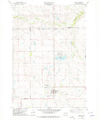
The boundary between Ziebach Co and Dewey Co runs through the western edge of this landscape, situated entirely within the Cheyenne River Indian Reservation. The terrain is defined by the winding course of Red Earth Creek, which cuts through the central and southern portions of the territory. This 1978 survey illustrates the rural character of the region during the late 1970s, where movement was primarily dictated by unimproved roads and established field lines across the open prairie. Further north, the waters of Meadow Creek drain toward the east, while Jewitt Pond sits near the southern border, providing a rare permanent water source in an area largely characterized by its intermittent drainage patterns and cattle-grazing land.
Find a feature on this map
4 named features on this map. Tap any name to fly to it.
Don’t see what you’re looking for? This feature index may not catch every label — zoom into the map to look around manually.
Map Details
Editions of this 1978 Isabel SW Map
This is the sole edition of this map. No revisions or reprints were ever made.
Other maps of this area

1951 · Dupree NE
USGS Topo · 1:24,000

1952 · Lantry NW
USGS Topo · 1:24,000

1952 · Lantry NE
USGS Topo · 1:24,000

1953 · McIntosh
USGS Topo · 1:250,000

1958 · McIntosh
USGS Topo · 1:250,000

1978 · Peach Lake
USGS Topo · 1:24,000
1978 · Isabel
USGS Topo · 1:24,000

1978 · Firesteel
USGS Topo · 1:24,000

1982 · Irish Creek SE
USGS Topo · 1:24,000
1983 · Irish Creek NE
USGS Topo · 1:24,000