
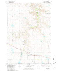
1951 Map of Dupree NE
USGS Topo · Published 1953About this map
The Cheyenne River Indian Reservation dominates this 1951 topographic study of northern Ziebach County, showing a landscape defined by the winding course of the Moreau River. The river creates a series of complex meanders and oxbows as it cuts through the high plains, flanked by prominent elevations like Gray Butte and St Patrick Butte. This terrain is deeply etched by a network of drainage systems, including East Trail Creek, Ash Creek, and Sandrock Creek, which flow toward the river valley.
Find a feature on this map
12 named features on this map. Tap any name to fly to it.
Don’t see what you’re looking for? This feature index may not catch every label — zoom into the map to look around manually.
Map Details
Editions of this 1951 Dupree NE Map
This is the sole edition of this map. No revisions or reprints were ever made.
Other maps of this area

1951 · Thunder Butte
USGS Topo · 1:24,000

1952 · Lantry NW
USGS Topo · 1:24,000

1953 · McIntosh
USGS Topo · 1:250,000

1958 · McIntosh
USGS Topo · 1:250,000

1978 · Isabel SW
USGS Topo · 1:24,000
1979 · Dupree
USGS Topo · 1:25,000
1981 · Lantry
USGS Topo · 1:24,000

1982 · Irish Creek SW
USGS Topo · 1:24,000

1982 · Irish Creek SE
USGS Topo · 1:24,000
1986 · Timber Lake
USGS Topo · 1:100,000