1981 Map of Lantry
USGS Topo · Published 1982About this map
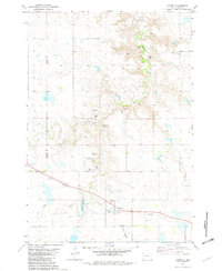
Lantry serves as the focal point for this survey of the western South Dakota plains, situated along the county line where Ziebach Co meets Dewey Co. The landscape is defined by the drainage of Bear Creek and Little Bear Creek, which feed into Lantry Lake. Local social and religious infrastructure is represented by the Community Hall and the Trailer Park, while burial grounds like St James Cem and Lantry Cem provide points of interest for genealogical research. The map captures a moment when the regional transportation network was in transition, showing a rail line marked Abandoned running through the heart of the settlement. Small-scale aviation and roadside amenities are present via the Mc Daniel Landing Strip and a Roadside Park, while numerous Gravel Pits and a Drill Hole indicate local resource extraction activities during the early 1980s.
Find a feature on this map
18 named features on this map. Tap any name to fly to it.
Don’t see what you’re looking for? This feature index may not catch every label — zoom into the map to look around manually.
Map Details
Editions of this 1981 Lantry Map
This is the sole edition of this map. No revisions or reprints were ever made.
Other maps of this area

1951 · Dupree NE
USGS Topo · 1:24,000

1952 · Lantry NW
USGS Topo · 1:24,000

1952 · Lantry NE
USGS Topo · 1:24,000

1953 · McIntosh
USGS Topo · 1:250,000

1954 · Pierre
USGS Topo · 1:250,000

1958 · Pierre
USGS Topo · 1:250,000

1958 · McIntosh
USGS Topo · 1:250,000
1979 · Dupree
USGS Topo · 1:25,000

1981 · High Elk Hill NW
USGS Topo · 1:24,000

1981 · High Elk Hill
USGS Topo · 1:24,000