
1982 Map of Irish Creek SW
USGS Topo · Published 1983About this map
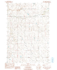
Cheyenne River Indian Reservation lands dominate this prairie landscape in Ziebach County, where a network of seasonal watercourses defines the topography. The drainage system is characterized by the confluence of East Beaver Trap Creek and West Beaver Trap Creek, which merge into the main stem of Beaver Trap Creek as it winds southward. These creek beds and the nearby Sophia Creek provided critical water sources in a region where settlement was sparse and largely dictated by the availability of surface water. A notable human landmark in this section of the plains is the Dorsey Landing Strip, positioned near the western edge of the survey area. Farther east, Irish Creek meanders through the breaks, illustrating the classic erosional patterns of the South Dakota backcountry in the early 1980s.
Find a feature on this map
9 named features on this map. Tap any name to fly to it.
Don’t see what you’re looking for? This feature index may not catch every label — zoom into the map to look around manually.
Map Details
Editions of this 1982 Irish Creek SW Map
This is the sole edition of this map. No revisions or reprints were ever made.
Other maps of this area

1951 · Redelm NE
USGS Topo · 1:24,000

1951 · Dupree NE
USGS Topo · 1:24,000

1951 · Thunder Butte
USGS Topo · 1:24,000

1953 · McIntosh
USGS Topo · 1:250,000

1958 · McIntosh
USGS Topo · 1:250,000

1982 · Glad Valley
USGS Topo · 1:24,000

1982 · Irish Creek NW
USGS Topo · 1:24,000

1982 · Glad Valley SE
USGS Topo · 1:24,000

1982 · Irish Creek SE
USGS Topo · 1:24,000
1983 · Irish Creek NE
USGS Topo · 1:24,000