
1982 Map of Glad Valley SE
USGS Topo · Published 1983About this map
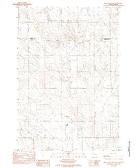
Thunder Butte serves as the dominant landmark of this prairie landscape in Ziebach County, overlooking a network of seasonal watercourses. The drainage patterns are defined by the convergence of West Beaver Trap Creek and East Beaver Trap Creek, which carve through the open terrain of the Cheyenne River Indian Reservation. In the southern portion of the map, the more prominent Thunder Butte Creek winds along the base of its namesake height, illustrating the characteristic erosion of the West River region. This 1982 survey reflects the sparse human footprint in this part of South Dakota, where the land remains largely defined by its natural contours and the sectional boundaries of township and range lines.
Find a feature on this map
6 named features on this map. Tap any name to fly to it.
Don’t see what you’re looking for? This feature index may not catch every label — zoom into the map to look around manually.
Map Details
Editions of this 1982 Glad Valley SE Map
This is the sole edition of this map. No revisions or reprints were ever made.
Other maps of this area

1951 · Redelm NE
USGS Topo · 1:24,000

1951 · Redelm NW
USGS Topo · 1:24,000

1951 · Thunder Butte
USGS Topo · 1:24,000

1953 · McIntosh
USGS Topo · 1:250,000

1958 · McIntosh
USGS Topo · 1:250,000

1982 · Glad Valley
USGS Topo · 1:24,000

1982 · Glad Valley SW
USGS Topo · 1:24,000

1982 · Glad Valley NW
USGS Topo · 1:24,000

1982 · Irish Creek SW
USGS Topo · 1:24,000
1982 · Irish Creek NW
USGS Topo · 1:24,000