
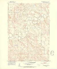
1951 Map of Thunder Butte
USGS Topo · Published 1953About this map
The Cheyenne River Indian Reservation landscape is defined by the winding course of the Moreau River, which carves a deep valley through the northern plains of South Dakota. In the early 1950s, this area remained largely dominated by river-and-creek geography, with numerous crossings indicated by Ford labels along the riverbanks. The prominent landmark of Thunder Butte rises above its namesake Thunder Butte Creek, providing a focal point for the surrounding terrain. Small pockets of community infrastructure are visible, including the High Point Sch and St Luke Cem, reflecting the sparse but established rural life within the reservation during the mid-century era. The map also documents hydrological features like Spillway 2264, part of the larger development of the Missouri River Basin.
Find a feature on this map
14 named features on this map. Tap any name to fly to it.
Don’t see what you’re looking for? This feature index may not catch every label — zoom into the map to look around manually.
Map Details
Editions of this 1951 Thunder Butte Map
2 editions found
Other maps of this area

1951 · Redelm NE
USGS Topo · 1:24,000

1951 · Dupree NE
USGS Topo · 1:24,000

1953 · McIntosh
USGS Topo · 1:250,000

1958 · McIntosh
USGS Topo · 1:250,000

1979 · Dupree
USGS Topo · 1:25,000

1982 · Irish Creek SW
USGS Topo · 1:24,000
1982 · Red Elm
USGS Topo · 1:24,000

1982 · Glad Valley SE
USGS Topo · 1:24,000
1982 · Irish Creek SE
USGS Topo · 1:24,000
1986 · Timber Lake
USGS Topo · 1:100,000