Loading...
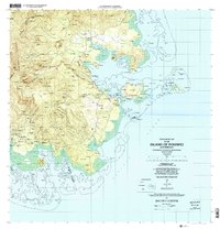
Loading map...2001 Map of Island Of Pohnpei (Southeast)
USGS Topo · Published 2002About this map
Madolenihmw Municipality defines the southeastern coastline of Pohnpei, where the landscape transitions from the high interior peaks of the Pohnpei Watershed Forest Reserve to a complex network of bays and mangrove-lined estuaries. This 2001 survey captures a period of careful resource management, evidenced by the designation of protected areas such as the Namwen Na Na Marine Sanctuary and Namwen Nahnning Marine Sanctuary along the eastern reefs.
Find a feature on this map
234 named features on this map. Tap any name to fly to it.
Don’t see what you’re looking for? This feature index may not catch every label — zoom into the map to look around manually.
Map Details
Date Portrayed2001
Date Published2002
PublisherU.S. Geological Survey
Map TypeTopographic
Scale1:25,000
Physical Dimensions28.6 x 29.8 inches
Editions of this 2001 Island Of Pohnpei (Southeast) Map
This is the sole edition of this map. No revisions or reprints were ever made.
Other maps of this area
Featured Places
Source Details
SourceU.S. Geological Survey
CopyrightPublic Domain