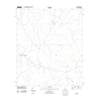
2011 Map of Isney
USGS Topo · Published 2011About this map
Isney and Emory anchor this rural landscape in southwestern Choctaw County, illustrating a community defined by its waterways and energy resources. The terrain is intricately carved by Buckatunna Creek and Puss Cuss Creek, with several family-named landmarks such as John Green Pond and the Sanderson Pond Dam reflecting local land use. For genealogists and local historians, the placement of the Salem Cemetery, Old Bethel Cemetery, and Loften Cemetery provides essential geographic context for early residents.
Find a feature on this map
48 named features on this map. Tap any name to fly to it.
Don’t see what you’re looking for? This feature index may not catch every label — zoom into the map to look around manually.
Map Details
Editions of this 2011 Isney Map
This is the sole edition of this map. No revisions or reprints were ever made.
Other maps of this area

1953 · Hattiesburg
USGS Topo · 1:250,000

1958 · Hattiesburg
USGS Topo · 1:250,000

1964 · Carmichael
USGS Topo · 1:24,000

1964 · Denham
USGS Topo · 1:24,000

1964 · Matherville
USGS Topo · 1:24,000

1974 · Melvin
USGS Topo · 1:24,000

1974 · Millry North
USGS Topo · 1:24,000

1974 · Silas
USGS Topo · 1:24,000

1974 · Isney
USGS Topo · 1:24,000
1974 · Aquilla
USGS Topo · 1:24,000