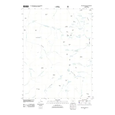
2011 Map of Isolation Peak
USGS Topo · Published 2011About this map
The Continental Divide anchors this high-elevation landscape within Wild Basin, where glacial activity has carved out a complex system of alpine lakes and hanging valleys. From the sheer walls of The Cleaver to the icy reaches of Moomaw Glacier and the Saint Vrain Glaciers, the terrain dictates the drainage patterns for North Saint Vrain Creek and the East Inlet. A notable human imprint on this wilderness is the Bluebird Dam, located at the head of Ouzel Creek. The map documents a dense concentration of named water bodies, including Lake Verna, Thunder Lake, and Spirit Lake, which served as vital landmarks for early surveying parties. Named summits such as Mount Irving Hale and Isolation Peak define the horizon, marking the boundaries of watersheds that feed both the Colorado River and Atlantic slopes.
Find a feature on this map
87 named features on this map. Tap any name to fly to it.
Don’t see what you’re looking for? This feature index may not catch every label — zoom into the map to look around manually.
Map Details
Editions of this 2011 Isolation Peak Map
This is the sole edition of this map. No revisions or reprints were ever made.
Other maps of this area

1915 · Longs Peak
USGS Topo · 1:125,000

1919 · Rocky Mountain National Park
USGS Topo · 1:125,000

1954 · Greeley
USGS Topo · 1:250,000

1957 · Greeley
USGS Topo · 1:250,000

1957 · Mc Henrys Peak
USGS Topo · 1:24,000

1957 · Allens Park
USGS Topo · 1:24,000

1957 · Longs Peak
USGS Topo · 1:24,000
1957 · Ward
USGS Topo · 1:24,000

1958 · Greeley
USGS Topo · 1:250,000
1958 · Strawberry Lake
USGS Topo · 1:24,000