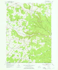
1954 Map of Ivory
USGS Topo · Published 1976About this map
Chautauqua County hill country is defined by steep ridges and narrow creek valleys in the mid-1950s, centering on the small settlement of Ivory. The landscape is etched with local history, from the high grounds of Oak Hill and Wheeler Hill to the rural congregational hubs at Oak Hill Ch and Wheeler Hill Ch. Significant family-named landmarks and roads like Fisher Hill Road and Emory Road trace the migration and settlement patterns of this corner of Carroll and Poland townships.
Find a feature on this map
46 named features on this map. Tap any name to fly to it.
Don’t see what you’re looking for? This feature index may not catch every label — zoom into the map to look around manually.
Map Details
Editions of this 1954 Ivory Map
4 editions found
Other maps of this area

1905 · Jamestown
USGS Topo · 1:62,500

1906 · Warren
USGS Topo · 1:62,500

1907 · Warren
USGS Topo · 1:62,500

1908 · Warren
USGS Topo · 1:62,500

1922 · Randolph
USGS Topo · 1:62,500

1923 · Randolph
USGS Topo · 1:62,500

1936 · Kinzua
USGS Topo · 1:48,000

1941 · Kinzua
USGS Topo · 1:62,500

1942 · Jamestown
USGS Topo · 1:62,500

1943 · Randolph
USGS Topo · 1:62,500