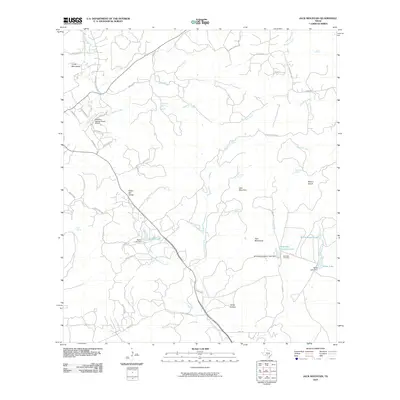
2010 Map of Jack Mountain
USGS Topo · Published 2010About this map
Jack Mountain and the surrounding Hill Country terrain define this landscape as it appeared in the early 21st century. The map reveals a complex network of ranch roads and residential drives, such as Madrona Ranch Rd and Skyview Dr, reflecting the area's transition toward rural estate development. Water management is a central feature of the local geography, shown by several impoundments and named springs, including Beekman Spring and Wolf Head Spring. Local history is anchored by the Heimsath Cemetery and the adjacent Heimsath Cemetery Lake, providing a clear focal point for genealogical research. The presence of the Freedom Springs Ranch Airport and landmarks like Cedar Hill Divide further illustrate the modern utilization of this traditional ranching landscape.
Find a feature on this map
58 named features on this map. Tap any name to fly to it.
Don’t see what you’re looking for? This feature index may not catch every label — zoom into the map to look around manually.
Map Details
Editions of this 2010 Jack Mountain Map
This is the sole edition of this map. No revisions or reprints were ever made.
Other maps of this area

1953 · Helotes
USGS Topo · 1:24,000

1953 · Van Raub
USGS Topo · 1:24,000

1954 · San Antonio
USGS Topo · 1:250,000

1956 · Comfort
USGS Topo · 1:62,500

1956 · Medina Lake
USGS Topo · 1:62,500

1957 · Boerne
USGS Topo · 1:62,500

1957 · San Antonio
USGS Topo · 1:250,000

1964 · Boerne
USGS Topo · 1:24,000

1964 · Medina Lake
USGS Topo · 1:24,000
1964 · Ranger Creek
USGS Topo · 1:24,000