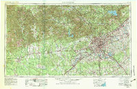
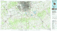
1957 Map of San Antonio
USGS Topo · Published 1957About this map
San Antonio serves as the central hub for this mid-century survey, surrounded by a ring of strategic aviation centers including Randolph AFB and Kelly AFB. The landscape is sharply defined by the Balcones Escarpment, which separates the hilly Edwards Plateau terrain to the northwest from the flatter coastal plains. This geological transition is marked by the course of the Guadalupe River and the Medina River, which flow toward the Gulf. To the west, the map details the rugged topography around Meridian Mountain and Garner State Park. The region's infrastructure in the 1950s was heavily influenced by rail lines like the Southern Pacific and Texas and New Orleans, which connected outlying settlements such as Hondo, Uvalde, and New Braunfels to the growing urban core.
Find a feature on this map
160 named features on this map. Tap any name to fly to it.
Don’t see what you’re looking for? This feature index may not catch every label — zoom into the map to look around manually.
Map Details
Editions of this 1957 San Antonio Map
This is the sole edition of this map. No revisions or reprints were ever made.
Historical Maps of San Antonio Through Time
3 maps found