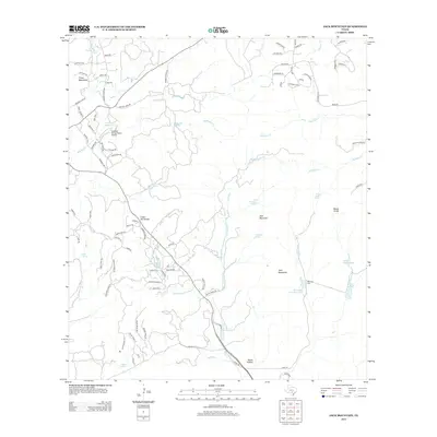
2013 Map of Jack Mountain
USGS Topo · Published 2013About this map
Jack Mountain and the prominent Cedar Hill Divide anchor this Texas Hill Country landscape, where the headwaters of numerous creeks begin their descent toward the south and east. The drainage pattern is defined by the San Geronimo Cr and Balcones Cr, with smaller catchments like S Fork Sangeronimo Cr and Madrona Cr carving through the terrain. Human activity is marked by a network of ranch roads and residential loops, alongside the private Freedom Springs Ranch Airport. For those looking into local genealogy and land use, the map identifies the Heimsath Cem near the banks of Heimsath Cemetery Lake, and names several water sources including Beekman Spring and Wolf Head Spring. The western edge features roads named Chisholm Trl and Cheyenne Trl, reflecting the region's enduring connection to historic trail names.
Find a feature on this map
93 named features on this map. Tap any name to fly to it.
Don’t see what you’re looking for? This feature index may not catch every label — zoom into the map to look around manually.
Map Details
Editions of this 2013 Jack Mountain Map
This is the sole edition of this map. No revisions or reprints were ever made.
Other maps of this area

1953 · Helotes
USGS Topo · 1:24,000

1953 · Van Raub
USGS Topo · 1:24,000

1954 · San Antonio
USGS Topo · 1:250,000

1956 · Comfort
USGS Topo · 1:62,500

1956 · Medina Lake
USGS Topo · 1:62,500

1957 · Boerne
USGS Topo · 1:62,500

1957 · San Antonio
USGS Topo · 1:250,000

1964 · Boerne
USGS Topo · 1:24,000

1964 · Medina Lake
USGS Topo · 1:24,000
1964 · Ranger Creek
USGS Topo · 1:24,000