
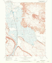
2017 Map of Jackass Butte NE
USGS Topo · Published 2017About this map
Diamond Craters dominates the southern landscape of this Harney County region, showcasing a complex volcanic field of vents and depressions. The hydraulic modification of the arid basin is evident through the winding course of the Donner und Blitzen River and the artificial channel of the Busse Canal, which divert water through the desert flats. A sparse network of roads, including the Sodhouse road and the Narrows-Princeton Rd, connects this remote high-desert environment. The map records a landscape defined by large-scale public land divisions like t27s r31e and t28s r32e, where water management and volcanic geology are the primary features of interest.
Find a feature on this map
11 named features on this map. Tap any name to fly to it.
Don’t see what you’re looking for? This feature index may not catch every label — zoom into the map to look around manually.
Map Details
Editions of this 2017 Jackass Butte NE Map
This is the sole edition of this map. No revisions or reprints were ever made.
Other maps of this area

1955 · Burns
USGS Topo · 1:250,000

1958 · Burns
USGS Topo · 1:250,000

1959 · Burns
USGS Topo · 1:250,000

1959 · Lawen
USGS Topo · 1:62,500

1960 · Crane
USGS Topo · 1:62,500

1967 · Coyote Buttes
USGS Topo · 1:24,000

1967 · Jackass Butte
USGS Topo · 1:24,000

1967 · Jackass Butte NE
USGS Topo · 1:24,000

1967 · Barton Lake
USGS Topo · 1:24,000
1967 · Diamond Swamp
USGS Topo · 1:24,000