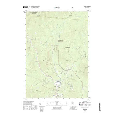
2018 Map of Jackson
USGS Topo · Published 2018About this map
The Ellis River and Wildcat Brook converge near the heart of Jackson, a region defined by its complex network of recreational trails and high-elevation terrain. This 2018 survey documents the intricate topography of the southern White Mountain National Forest, where the Appalachian National Scenic Trail traverses the Wildcat Ridge. Significant vertical relief is mapped through numerous peaks including Black Mtn, Eagle Mtn, and the distinctive North Doublehead. Local landmarks like the Honeymoon Bridge and Jackson Falls emphasize the area's river-centric development, while specialized routes such as the Doublehead Ski Trail (Snow) and Bald Land Trail highlight the long-standing importance of mountain tourism. Smaller settlements and named locales like Ducks Head, Dundee, and Goodrich Falls provide specific points of interest for genealogists and local historians studying Carroll County's residential footprint in the early 21st century.
Find a feature on this map
92 named features on this map. Tap any name to fly to it.
Don’t see what you’re looking for? This feature index may not catch every label — zoom into the map to look around manually.
Map Details
Editions of this 2018 Jackson Map
This is the sole edition of this map. No revisions or reprints were ever made.
Other maps of this area

1893 · Mt. Washington
USGS Topo · 1:62,500

1893 · Gorham
USGS Topo · 1:62,500

1894 · North Conway
USGS Topo · 1:62,500

1895 · Crawford Notch
USGS Topo · 1:62,500

1896 · Mt. Washington
USGS Topo · 1:62,500

1896 · Crawford Notch
USGS Topo · 1:62,500

1896 · North Conway
USGS Topo · 1:62,500

1896 · Gorham
USGS Topo · 1:62,500

1935 · Mt. Washington
USGS Topo · 1:62,500

1937 · Gorham
USGS Topo · 1:48,000