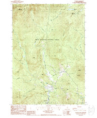
1987 Map of Jackson
USGS Topo · Published 1987About this map
Jackson sits at the heart of this White Mountain landscape, where the confluence of Wildcat Brook and the Ellis River creates a corridor of settlement and recreation. By the late 1980s, the area's transition into a seasonal destination is evident through features like the Black Mountain Ski Trail and Mirror Lake. The map details the complex drainage systems flowing from the surrounding peaks, including Winniweta Falls and Jackson Falls, which historically powered local industry before the region's shift toward tourism. To the south, Goodrich Falls marks the river's path into Bartlett. Further east, the small settlement of Dundee is tucked between Middle Mtn and Thorn Mtn. The vast northern expanse of Beans Purchase remains largely undeveloped, characterized by remote high-country features such as No Ketchum Pond and the high elevations of Black Mountain.
Find a feature on this map
48 named features on this map. Tap any name to fly to it.
Don’t see what you’re looking for? This feature index may not catch every label — zoom into the map to look around manually.
Map Details
Editions of this 1987 Jackson Map
This is the sole edition of this map. No revisions or reprints were ever made.
Other maps of this area

1893 · Mt. Washington
USGS Topo · 1:62,500

1893 · Gorham
USGS Topo · 1:62,500

1894 · North Conway
USGS Topo · 1:62,500

1895 · Crawford Notch
USGS Topo · 1:62,500

1896 · Mt. Washington
USGS Topo · 1:62,500

1896 · Crawford Notch
USGS Topo · 1:62,500

1896 · North Conway
USGS Topo · 1:62,500

1896 · Gorham
USGS Topo · 1:62,500

1935 · Mt. Washington
USGS Topo · 1:62,500

1937 · Gorham
USGS Topo · 1:48,000