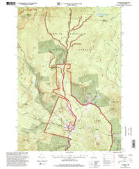
1995 Map of Jackson
USGS Topo · Published 2000About this map
Jackson sits at the heart of this mid-1990s survey, situated where Wildcat Brook meets the Ellis River. The map illustrates a landscape defined by the intersection of mountain recreation and small-town New Hampshire life, showing the village center with its distinctive Covered Bridge, Jackson Falls, and the local Cemetery. Notable for its complex topography, the area is bounded by the high peaks of Wildcat Mountain, Thorn Mountain, and Iron Mountain, which direct the flow of the Wildcat Brook Wild and Scenic River southward toward the Saco River.
Find a feature on this map
51 named features on this map. Tap any name to fly to it.
Don’t see what you’re looking for? This feature index may not catch every label — zoom into the map to look around manually.
Map Details
Editions of this 1995 Jackson Map
This is the sole edition of this map. No revisions or reprints were ever made.
Other maps of this area

1893 · Mt. Washington
USGS Topo · 1:62,500

1893 · Gorham
USGS Topo · 1:62,500

1894 · North Conway
USGS Topo · 1:62,500

1895 · Crawford Notch
USGS Topo · 1:62,500

1896 · Mt. Washington
USGS Topo · 1:62,500

1896 · Crawford Notch
USGS Topo · 1:62,500

1896 · North Conway
USGS Topo · 1:62,500

1896 · Gorham
USGS Topo · 1:62,500

1935 · Mt. Washington
USGS Topo · 1:62,500

1937 · Gorham
USGS Topo · 1:48,000