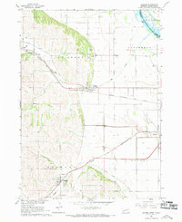
1967 Map of Jackson
USGS Topo · Published 1969About this map
The Missouri River and Big Sioux join in the northeastern corner of this landscape, marking the intersection of Nebraska, South Dakota, and Iowa. This 1967 survey captures the distinct transition from the river bottomlands to the rising bluffs and hills of the St Johns and Hubbard precincts. A major rail corridor centers on Jackson, where the Chicago Burlington and Quincy tracks align through the valley floor. To the south, the village of Hubbard sits near the headwaters of Jones Creek and Pigeon Creek, which have been partially redirected via the Pigeon Creek Ditch. The presence of St Johns Cem and St Marys Cem provides specific points of interest for genealogists tracing family roots in these early farming communities. Land use is characterized by a grid of field lines and property boundaries, interspersed with active resource extraction at the Gravel Pit near the northern bluffs.
Find a feature on this map
24 named features on this map. Tap any name to fly to it.
Don’t see what you’re looking for? This feature index may not catch every label — zoom into the map to look around manually.
Map Details
Editions of this 1967 Jackson Map
2 editions found
Other maps of this area

1898 · Elk Point
USGS Topo · 1:125,000

1901 · Elk Point
USGS Topo · 1:125,000

1907 · Elk Point
USGS Topo · 1:125,000

1955 · Sioux City
USGS Topo · 1:250,000

1958 · Sioux City
USGS Topo · 1:250,000

1959 · Sioux City
USGS Topo · 1:250,000

1963 · Sioux City South
USGS Topo · 1:24,000

1963 · Sioux City North
USGS Topo · 1:24,000

1963 · Jefferson
USGS Topo · 1:24,000
1964 · Ponca
USGS Topo · 1:24,000
Featured Places
- Dakota Dunes, Big Sioux Township
- Hubbard, Hubbard Precinct
- Jackson, St. Johns Precinct
- St. Johns Precinct, NE
- Dakota Precinct, NE