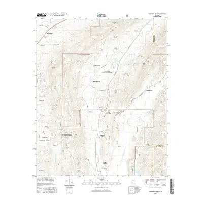
2014 Map of Jacksonville East
USGS Topo · Published 2014About this map
Talladega National Forest dominates the central and eastern portions of this quadrangle, preserving a landscape defined by the ridgelines of Chimney Mtn and Choccolocco Mtn. This 2014 survey documents the eastern outskirts of Jacksonville and the rural communities of Rabbittown, White Plains, and Holley Crossroads. A concentration of family-named cemeteries such as McCain Cem, Boozer Cem, and Williamson Little Cem underscores the deep-rooted settlement history along the valleys of Cottaquilla Cr and Nances Creek. The map provides an intricate look at local hydrology, from the Shelton Lakes to numerous natural springs like Roberts Spring and Watsons House Spring, illustrating how water sources influenced the placement of early homesteads and current road networks like Al-9 and Al-21.
Find a feature on this map
95 named features on this map. Tap any name to fly to it.
Don’t see what you’re looking for? This feature index may not catch every label — zoom into the map to look around manually.
Map Details
Editions of this 2014 Jacksonville East Map
This is the sole edition of this map. No revisions or reprints were ever made.
Other maps of this area

1900 · Anniston
USGS Topo · 1:125,000

1947 · Anniston
USGS Topo · 1:24,000

1947 · Colvin Gap
USGS Topo · 1:24,000

1947 · Jacksonville
USGS Topo · 1:24,000

1947 · Jacksonville
USGS Topo · 1:62,500

1950 · Anniston
USGS Topo · 1:62,500

1953 · Atlanta
USGS Topo · 1:250,000

1954 · Choccolocco
USGS Topo · 1:24,000

1956 · Anniston
USGS Topo · 1:24,000
1956 · Jacksonville
USGS Topo · 1:24,000