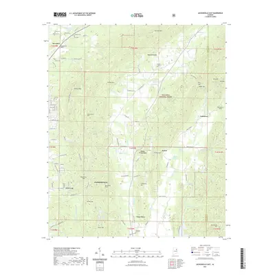
2021 Map of Jacksonville East
USGS Topo · Published 2021About this map
Talladega National Forest dominates the central and eastern portions of this survey, where the ridges of Choccolocco Mtn, Chimney Mtn, and Dugger Mtn create a natural barrier between rural valleys. In the northwest, the settlement of Merrellton sits near Carpenters Bend on the Tallaseehatchee Cr, while the eastern landscape is defined by the Choccolocco Valley and the community of Rabbittown. The map reveals a network of mountain gaps and springs that historically dictated local travel, including Whites Gap and Rabbittown Gap. Numerous small family and community burial grounds, such as McCain Cem, Nances Creek Cem, and the Williamson - Little Cem near White Plains, provide significant touchpoints for genealogical research. The presence of Shelton Lakes and Lake Cottaquilla indicates the importance of managed water resources in the undulating terrain of eastern Calhoun and western Cleburne counties.
Find a feature on this map
109 named features on this map. Tap any name to fly to it.
Don’t see what you’re looking for? This feature index may not catch every label — zoom into the map to look around manually.
Map Details
Editions of this 2021 Jacksonville East Map
This is the sole edition of this map. No revisions or reprints were ever made.
Other maps of this area

1900 · Anniston
USGS Topo · 1:125,000

1947 · Anniston
USGS Topo · 1:24,000

1947 · Colvin Gap
USGS Topo · 1:24,000

1947 · Jacksonville
USGS Topo · 1:24,000

1947 · Jacksonville
USGS Topo · 1:62,500

1950 · Anniston
USGS Topo · 1:62,500

1953 · Atlanta
USGS Topo · 1:250,000

1954 · Choccolocco
USGS Topo · 1:24,000

1956 · Anniston
USGS Topo · 1:24,000
1956 · Jacksonville
USGS Topo · 1:24,000