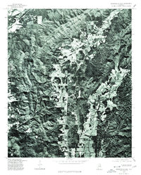
1975 Map of Jacksonville East
USGS Topo · Published 1977About this map
White Plains and the surrounding Calhoun County landscape are revealed in this 1975 orthophotoquad, which uses aerial photography to show the actual ground cover and land use patterns of the era. Unlike traditional topographic maps, this imagery captures the literal footprint of agriculture and forest management along Nances Creek and its adjacent valleys. The contrast between the wooded ridgelines and the cleared, rectilinear fields of the valley floor provides a clear look at how rural settlements and homesteads were integrated into the terrain during the mid-1970s. This specific survey was produced in cooperation with the Soil Conservation Service, highlighting the focus on land management and natural resources in this part of eastern Alabama.
Find a feature on this map
2 named features on this map. Tap any name to fly to it.
Don’t see what you’re looking for? This feature index may not catch every label — zoom into the map to look around manually.
Map Details
Editions of this 1975 Jacksonville East Map
This is the sole edition of this map. No revisions or reprints were ever made.
Other maps of this area

1900 · Anniston
USGS Topo · 1:125,000

1947 · Anniston
USGS Topo · 1:24,000

1947 · Colvin Gap
USGS Topo · 1:24,000

1947 · Jacksonville
USGS Topo · 1:24,000

1947 · Jacksonville
USGS Topo · 1:62,500

1950 · Anniston
USGS Topo · 1:62,500

1953 · Atlanta
USGS Topo · 1:250,000

1954 · Choccolocco
USGS Topo · 1:24,000

1956 · Anniston
USGS Topo · 1:24,000
1956 · Jacksonville
USGS Topo · 1:24,000