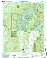
2001 Map of Jacksonville East
USGS Topo · Published 2004About this map
Choccolocco Mountain and Dugger Mountain dominate this landscape northeast of Jacksonville, where the transition from municipal limits to the protected acres of the Talladega National Forest is clearly defined. The terrain is marked by significant gaps and peaks, including Whites Gap and Chimney Mountain, the latter topped by the Chimney Peak Lookout. Smaller rural communities like Merrellton, Rabbittown, and White Plains anchor the valley floors, often situated near water sources such as Nances Creek and Cottaquilla Creek.
Find a feature on this map
56 named features on this map. Tap any name to fly to it.
Don’t see what you’re looking for? This feature index may not catch every label — zoom into the map to look around manually.
Map Details
Editions of this 2001 Jacksonville East Map
This is the sole edition of this map. No revisions or reprints were ever made.
Other maps of this area

1900 · Anniston
USGS Topo · 1:125,000

1947 · Anniston
USGS Topo · 1:24,000

1947 · Colvin Gap
USGS Topo · 1:24,000

1947 · Jacksonville
USGS Topo · 1:24,000

1947 · Jacksonville
USGS Topo · 1:62,500

1950 · Anniston
USGS Topo · 1:62,500

1953 · Atlanta
USGS Topo · 1:250,000

1954 · Choccolocco
USGS Topo · 1:24,000

1956 · Anniston
USGS Topo · 1:24,000
1956 · Jacksonville
USGS Topo · 1:24,000